After visiting John Wells at the Field Lab, we headed back down into Big Bend Park for some more exploring and picture taking.
Just inside the west entrance to the park, there is a turn off onto an unpaved road to the right. This is Old Maverick Road. It is a short cut, of sorts, down to Santa Elena Canyon. The paved road to the canyon is the main park road, to the junction of Ross Maxwell Scenic Drive, then down Ross Maxwell to Castalon, and from there down to the mouth of the canyon, a distance of around forty miles. Old Maverick Road gets you to the same destination in about fifteen rough, dusty miles.
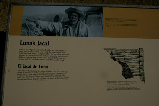
There are a few interesting sights to see along the way. The first you come upon, after about five miles, is Luna's Jacal. This is an old rock, mud, and stick house left over from the old days before the park. The old Mexican, Gilberto Luna, lived here for many years with his large family, until he died in 1947 at the venerable age of 108. We always stop here for some pictures when we come by.


Aside from all the beautiful scenery, and the occasional javelina, road runner, or coyote, the other interesting stop on Maverick Road is Terlingua Abaja. This is the site of an old farming community on the banks of the lower Terlingua Creek, hence the name. There are the ruins of some houses here, and a derelict 1920's automobile, slowly melting into the landscape. It's an interesting stop, but we didn't make the stop this year. It was getting late, so we pushed on down to the end of the road at the mouth of the canyon.
Parking in the little lot there, we noticed quite a few other vehicles there, also. There was a van full of elderly tourists disembarking, being lectured on the natural history of the area by a guide. They were from Far Flung Adventures, one of the major touring and river rafting outfitters in Terlingua.
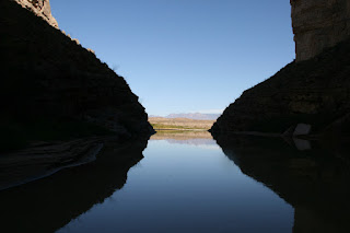
I was going to hike up into the canyon on the short nature trail. It goes up into the canyon for about a half a mile, to the spot where there is no more river bank, and it's just sheer canyon walls and river. Ok Hwa decided to stay near the parking lot, making pictures. There were several people nearby, with easels set up, making paintings of the dramatic canyon entrance.
To get to the canyon trail, you have to cross Terlingua Creek at the spot where it joins the Rio Grande. Depending on how recently it has rained, this crossing can be dry, muddy, or wading through flowing water. The water was flowing a little, but I was able to step across on a series of strategically placed stones, without getting muddy or wet.
On the other side the trail climbs quickly, through a series of switchbacks and poured concrete steps. This initial climb near the mouth of the canyon gets you to a great vantage point, high on the hillside, with a spectacular view of the desert and mountains in the distance to the east, the Terlingua Creek/Rio Grande junction in the foreground, across the river into Mexico off to the right, and, back to the west up into the canyon. This spot is really as far as most people really need to go. It's the most bang for the buck, so to speak.
It is a pleasant hike up into the canyon, though, and I love to explore, so even though I've hiked it before, I always like to do it again. It gets cool and secluded up in there quickly, especially in the afternoon. There's something majestic about the close proximity of all that massed rock formation, and the way the soft, but persistent river has cut a path right down through it over the ages.
I made it to the end of the trail in about twenty minutes. Along the way I passed a couple of middle aged gals, and we exchanged pleasantries. They caught up to me at the end of the trail. We took turns making pictures of each other with each other's cameras, like a bond between fellow explorers. You have to document the highest and farthest points on your travels.
Having duly communed with rock, water, flora, and fauna, I felt comfortable in returning to the relative civilization of the parking lot. Ok Hwa was having a great time making pictures down on the bank of the Rio Grande. She was fascinated, also, by all the folks there making paintings.
Back in the Bronco, we headed the eight miles downstream on the paved road to Castalon Village. Another ice cream on the porch there awaited us, then the beautiful drive back to Terlingua via the Ross Maxwell Scenic Drive.


No comments:
Post a Comment